,regionOfInterest=(1059.5,707))
,regionOfInterest=(1059.5,707))
The best hotels in Mallorca
,regionOfInterest=(1423.5,2124.5))
,regionOfInterest=(1423.5,2124.5))
HolidaysHotels
,regionOfInterest=(800,532.5))
,regionOfInterest=(800,532.5))
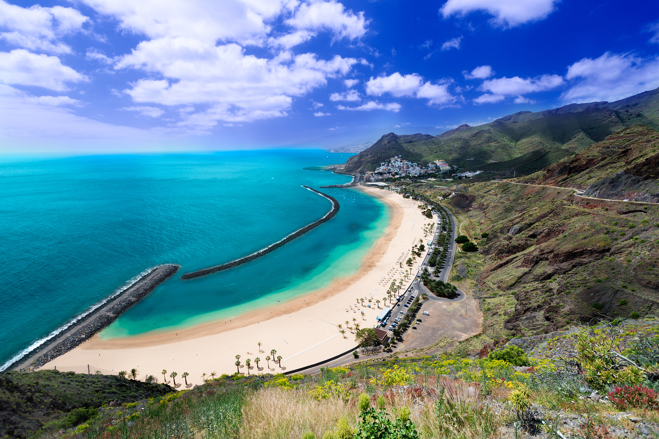
Tenerife has more than 1,500 km of signposted trails (PR and GR network) and four protected areas that concentrate the most spectacular routes: Teide National Park (18,990 ha, a UNESCO World Heritage Site), the Anaga Rural Park (laurisilva forest, a Biosphere Reserve), the Teno Rural Park (Masca, cliffs) and the Barranco del Infierno (Adeje). This guide brings together the essential routes with difficulty, distance, how to get there and what permits you need.
If the Teide is your specific goal, complement this page with the guide on how to visit the Teide in Tenerife; and if you are looking for an overview to plan your trip, the guide on what to see and do in Tenerife helps to link the routes with the rest of your plans.
Culture
,regionOfInterest=(512,482))
,regionOfInterest=(512,482))
Digital marketing specialist with a passion for travel, writing, and discovering what makes every destination unique.
,regionOfInterest=(800,532.5))
,regionOfInterest=(800,532.5))
,regionOfInterest=(1791,1200))
,regionOfInterest=(1791,1200))
,regionOfInterest=(3360,2240))
,regionOfInterest=(3360,2240))
| Route | Difficulty | Distance / Time | Permit / Booking |
| Roques de García (Teide) | Low | 3.5 km · 1h 30min | No |
| Pico del Teide (trail 10) | Medium | 2.5 km · 1-2h | Yes, with eco-tax (Tenerife ON) |
| Masca – Masca Beach | High | 4.5 km · 3-4h | Yes, with fee |
| Barranco del Infierno (Adeje) | Medium | 6.5 km · 3h | Yes, with entrance fee |
| Anaga: Chinamada – Punta del Hidalgo | Medium - high | 7.5 km · 4h | No |
| Anaga: Sendero de los Sentidos | Very low | 1.5 km · 45min | No |
| Chinyero (volcano) | Low - medium | 6.5 km · 2h 30min | No |
| Montaña Amarilla (El Médano) | Low | 1 km · 30min | No |
All signposted routes start from a car park or an accessible TITSA bus stop. Routes requiring a permit must be booked online days or weeks in advance depending on the season.
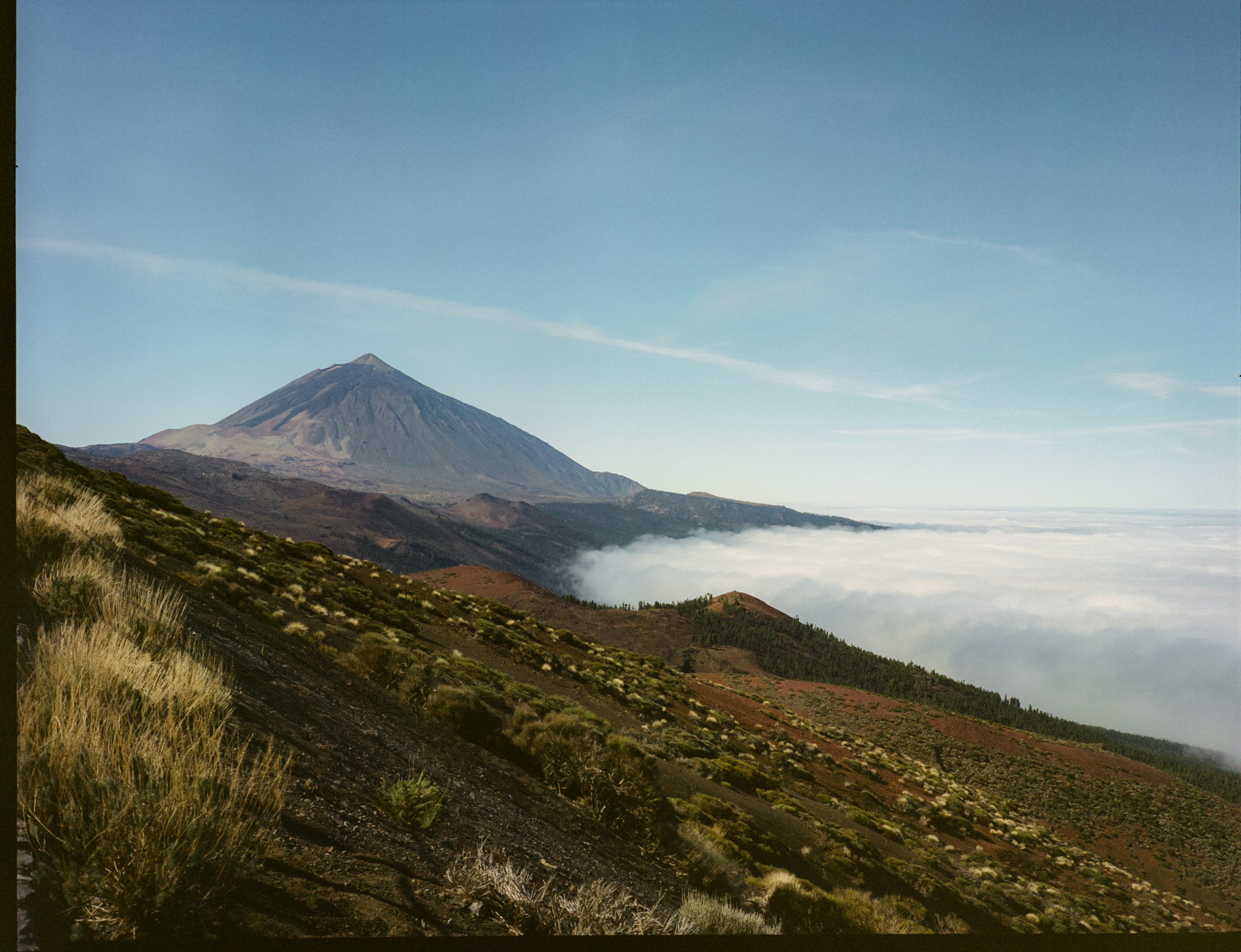
The Teide National Park concentrates the most visited routes on the island. With an altitude between 2,000 and 3,715 m, these are high mountain routes, although most are technically simple: the main challenge is the altitude, not the elevation.
The postcard of the park. 3.5 km circular route with an elevation of barely 170 m, completed in 1h 30min – 2h. The route passes by the Roque Cinchado (icon of the old 1,000 peseta banknote), Roque Blanco and the Cathedral, with views of the Las Cañadas caldera. The trail starts directly from the Parador Nacional car park and is ideal as a first contact with the park.
The ascent to the highest point in Spain (3,715 m). It is barely 2.5 km one way from the upper cable car station (La Rambleta, 3,555 m), with an elevation of 160 m, which takes between 30-45min. It requires mandatory processing of a permit 2-4 months in advance, which is managed exclusively on the official Tenerife ON platform.
,regionOfInterest=(1564,1200))
,regionOfInterest=(1564,1200))
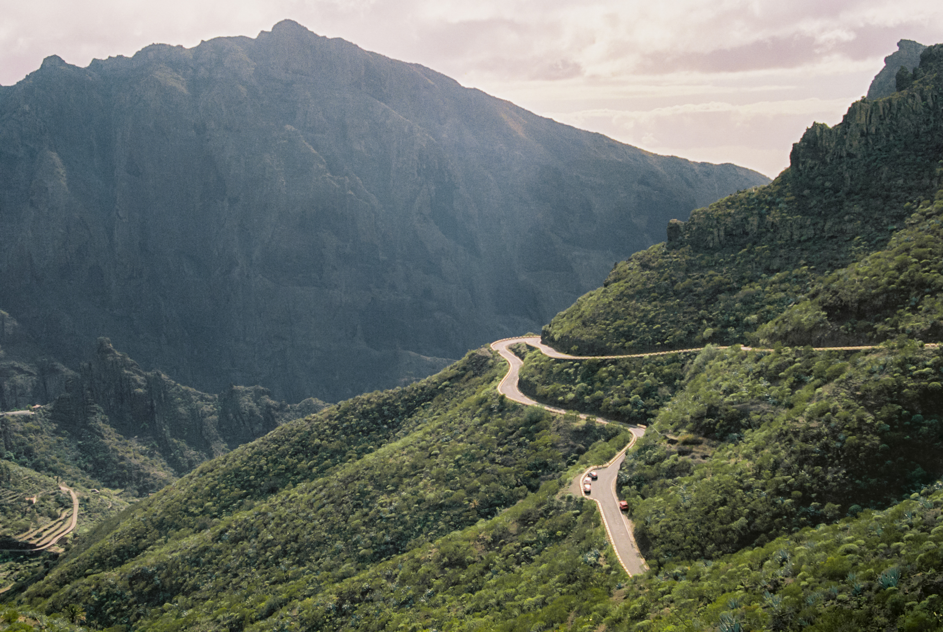
Anaga is the oldest massif in Tenerife and a UNESCO Biosphere Reserve, famous for its laurisilva (humid laurel forest) and for the rugged coast to the north. It is the opposite of the Teide: dense vegetation, cloudy atmosphere, deep ravines.
One of the most picturesque descent routes in Tenerife. It is a 4.7 km linear descent from the troglodyte hamlet of Chinamada (where the locals still live in houses carved into the rock) to Punta del Hidalgo, on the coast. It has a negative elevation of about 600 m and is completed in about 3-4h. Its difficulty is medium-high due to the impact of the descent. To return to the starting point, you can choose to use the TITSA buses or a taxi.
Very easy circular route, ideal for children. It offers 3 short options from 350 m to 1.5 km through the laurisilva forest. It starts from the Cruz del Carmen car park and has interpretive and interactive panels and signs designed to interact with nature through the senses. It takes approximately 30-60min to complete.
A fascinating set of traditional trails that connect the picturesque fishing villages in the north of Anaga. The wild Benijo Beach is the most iconic and photographed image of the massif; for all the details, complete with the guide on Benijo Beach.
The Masca trail is one of the most spectacular (and most demanding) routes in Tenerife. It descends for about 5 km along the Masca Ravine from the village of the same name to its secluded beach, where the return was historically done by boat. It closed in 2019 due to landslides and reopened with a protocol: daily quota, mandatory helmet, prepaid online booking.
From the Hacienda del Conde, in Buenavista del Norte, the village of Masca is a 20-minute drive away. To learn about the entire environment, check the guide on Los Gigantes cliffs.
,regionOfInterest=(1791,1200))
,regionOfInterest=(1791,1200))
The Barranco del Infierno is the star route in the south of Tenerife. It leaves from the historic centre of Adeje and runs along a permanent watercourse between gigantic rock walls to a waterfall almost 200 m high, consolidated as the highest continuous waterfall on the whole island. The entire environment is protected under the legal status of a Special Nature Reserve.
From the Meliá Jardines del Teide or the Gran Meliá Palacio de Isora, it is the perfect day route. It combines well with a subsequent visit to the most beautiful villages in Tenerife in the upper area of Adeje.
Not all routes require a full day. These options are short, perfectly signposted and suitable for families or for ending a day of excursions without much effort:
All are less than a 45-minute drive from the main accommodation areas.
The north is the ideal base area for routes in North Teide, Anaga and the pine forest of the Orotava Valley. If you are staying at the Sol Puerto de la Cruz or the Meliá Costa Atlantis you will have Anaga 50-60min away and the Teide 1h away by car.
Ideal base for exploring the Barranco del Infierno, South Teide (TF-21 / TF-38) and the Teno massif (Masca). From the Meliá Jardines del Teide, access to the Barranco del Infierno is 15min away; the Teide routes are 1h away and the hamlet of Masca is about 50min away.
The best base for thoroughly exploring Anaga. From the INNSiDE Santa Cruz you have access to the southern side of Anaga in just 20min and the central routes (Chinamada, Taganana, Benijo) are 30-40min away.
Unique base for Masca and the northwest side. From the Hacienda del Conde, Masca is 20min away and the entire Teno Rural Park is directly accessible.
,regionOfInterest=(1200,1791))
,regionOfInterest=(1200,1791))
The Tenerife climate allows for hiking all year round, but the optimal season depends on the area:
| Area | Best time | To avoid |
| Teide | Spring and autumn | Winter with snow, summer due to midday heat |
| Anaga | All year round | Days with heavy rain warnings |
| Teno / Masca | Spring and autumn | Days with strong wind or rain |
| Barranco del infierno | All year round | Rainy days (risk of landslides) |
| Southern coastal routes | Winter and spring | Midday in summer |
First thing in the morning is always optimal: fewer crowds, better temperature, ideal light for photos. Book your permits thinking of 8:00-10:00 slots when possible.
The combination of microclimates on a small island (sun, fog, wind, altitude) means that you have to prepare well even for short routes:
If you are travelling with children, check the guide on Tenerife with children: family plans for routes segmented by age.
,regionOfInterest=(4096,2732))
,regionOfInterest=(4096,2732))
,regionOfInterest=(2448,1632))
,regionOfInterest=(2448,1632))
,regionOfInterest=(3096,4128))
,regionOfInterest=(3096,4128))
,regionOfInterest=(3240,2160))
,regionOfInterest=(3240,2160))
,regionOfInterest=(1078,1609))
,regionOfInterest=(1078,1609))
,regionOfInterest=(3100,2066.5))
,regionOfInterest=(3100,2066.5))